Sunday, August 24, 2014
A little cold water doesn't scare me, I dive Monterey!
UK Dive Boy and the ALS Ice Bucket Challenge.

seeing something on the way back, which you saw on the way out ...
Little things like that give you a warm fuzzy feeling, when you're a scuba diver.
#navigationspecialty
#navigationspecialty
Friday, June 20, 2014
Tuesday, May 20, 2014
Dive to Metridium Fields, Monterey, CA
Managed a repeat of the Metridiums dive this weekend.
Visibility was about the same as last month, maybe a little better.
Took my GoPro this time, so captured some video of a Metridium. Unfortunately, I didn't have my green water filter on, so the colors are somewhat messed up.
Timeline for the video:
Visibility was about the same as last month, maybe a little better.
Took my GoPro this time, so captured some video of a Metridium. Unfortunately, I didn't have my green water filter on, so the colors are somewhat messed up.
Timeline for the video:
| Time Offset | Description |
|---|---|
| 0:00 | Urchin on the pipe |
| 0:30 | Traveling along the pipe (lots of sea stars |
| 1:10 | Into the murkiness |
| 1:40 | Arrival at the metridiums and a friendly nudi |
| 2:00 | Metridium panorama |
| 3:00 | Critter time: Sea hare? |
| 3:20 | Critter time: Lingcod |
| 4:05 | Critter time: Tiny Nudi (back on pipe) |
| 4:20 | Traveling back along the pipe in the murkiness |
| 5:20 | End |
Monday, May 19, 2014
Turtle in Belize
My son had been wanting to see a turtle the whole time we were diving in Belize. If fact, even before we got there. Luckily, on the last dive, of the last day, we got to see one!
And to think, we were supposed to be diving out at Turneffe Atol that day. Good job the trip got cancelled eh!
And to think, we were supposed to be diving out at Turneffe Atol that day. Good job the trip got cancelled eh!
Friday, May 16, 2014
Coral Reefs 101
http://www.padi.com/blog/2013/05/24/coral-reefs-101/
Well, I just learnt something, plus got a pining to go back to Belize :-)
Well, I just learnt something, plus got a pining to go back to Belize :-)
Sunday, April 27, 2014
Diving Metridium Fields Monterey, April 19, 2014
Dive Site
Metridiums Fields, San Carlos Beach, Monterey, California.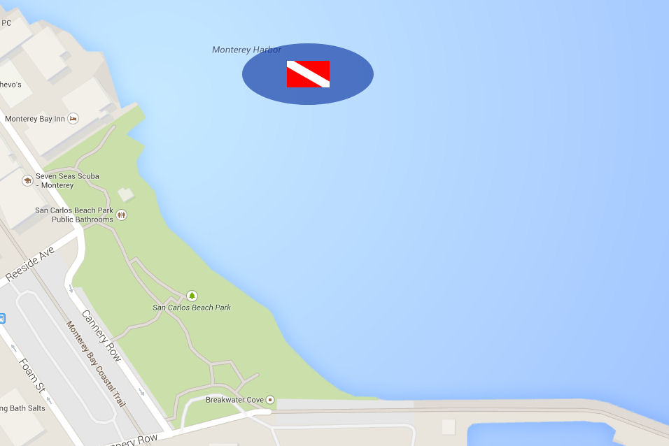
Click for fullsize image or Google Map
The Metridium Fields site is a beautiful dive site located at San Carlos beach in Monterey. San Carlos beach, also known as The Break Water by many local divers, is a very popular site. If you dive closer to the breakwater wall, you will be diving amongst the hordes of open water dive classes. However, further away from the wall, and a long swim from the shore, is the spectacular Metridium Fields.
Reaching the Metridium Fields requires a rather long swim. If you do it underwater this will limit your time at the dive site. If you do it on the surface you will be getting close to boat traffic. On this dive we had Diver Propultion Vehicles (DPVs), so we were able to do the descend quite close to the beach yet still have plenty of bottom time once we reach the metridiums.
Actually I was taking the PADI DPV specialty.
You enter the water from the left side of San Carlos beach. There are stairs down to the beach near the restroom at the left side of the parking lot. Before you go down to the beach, familiarize yourself with the location of the pump house just behind the restrooms, as that will be an important visual landmark for the start of the dive.
Be careful where you enter the water. At this side of the beach there are a number of submerged rocks, and also exposed rebar (metal) from the foundations of the old cannery buildings. The beach here is quite well protected, so waves are usually not too large. However, as I say the rocks and foundations can be a hazard and you don't want to fall here should a rogue wave come along.
Dive Plan, showing entry/exit, ascent/descent, and directions
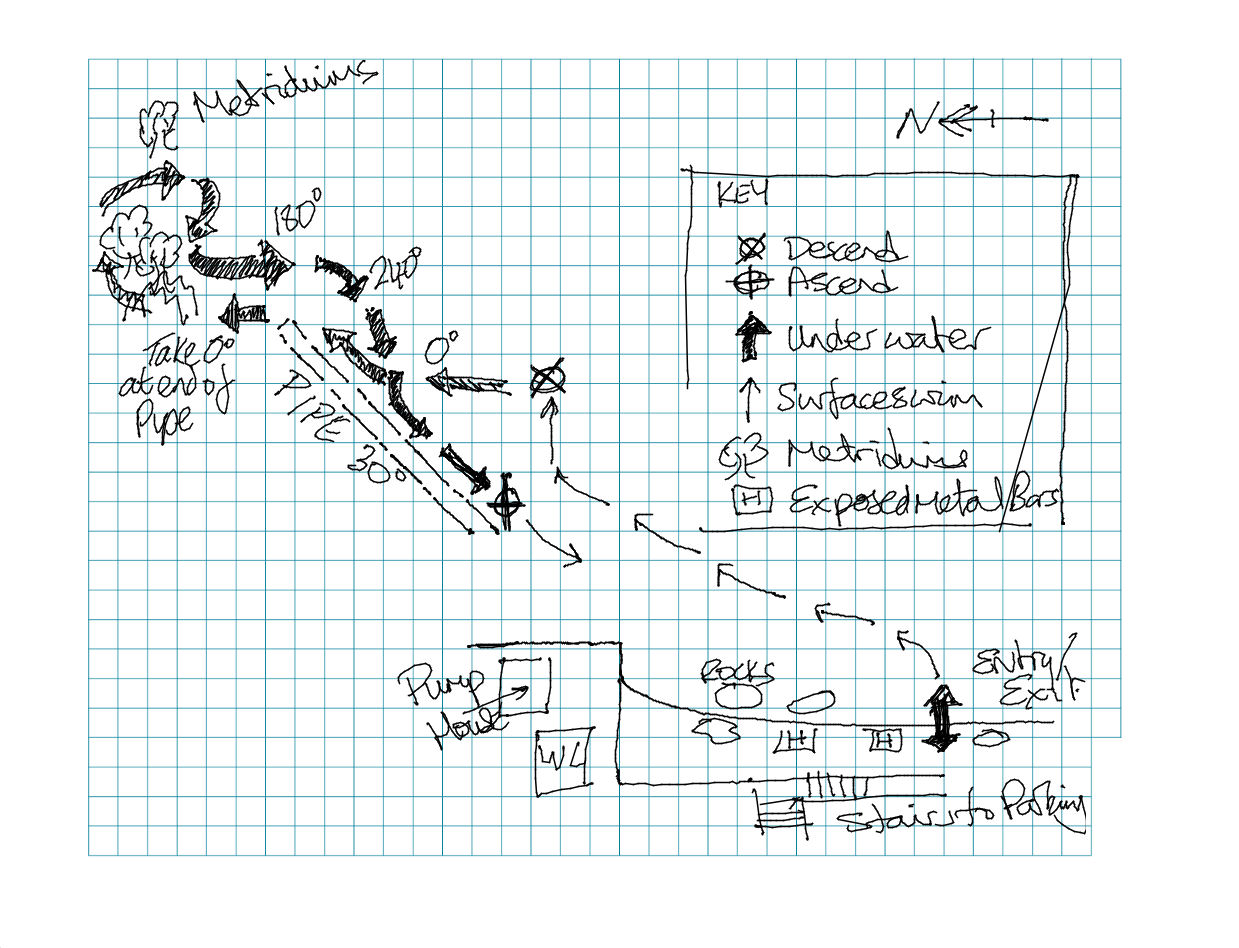
Click for fullsize image
After entering the water swim away from the beach and, if looking towards the beach, out to your right (northerly). The drop off here is slow, so you need to swim out a way before it's deep enough to descend. You need to head more northernly, as you need to line yourself up with the pump house on the shore. You can also see the road, Reeside Ave, going up the hill behind the pump house.
View from the ocean, GPS coordinates show where we surfaced
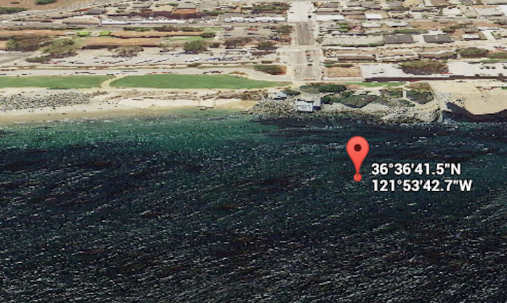
Click for fullsize image or Google Maps
Swim out away from the beach perpendicular to the pump house. As I said earlier, the further out you swim, the less swimming you need to do underwater to reach the Metridiums.
Take a bearing back to the beach before you drop down. Prefer a bearing towards the center of San Carlos beach rather than direct to the pump house, as you don't want to come ashore too far north here on your return - it's very rocky with no good beach north of the pump house.
Descend and head North. You should shortly hit the pipe. There are lots of small pipes around Monterey dive sites, don't be mistaken, at this dive site you are looking for a much larger pipe, about 2, or more, feet in diameter.
When you reach the pipe, follow the pipe out into deeper water (30degree heading). At the end of the pipe (the pipe ends abruptly) head North again. You will very soon hit the Metridium fields.
Once we reached the site we explored on a NE-SE direction. After completing the dive, we turned on a 180degree heading for a short while, to put us on a good path towards San Carlos beach, then turned to 240degrees. This put us on an intercept path with the pipe, which runs at 210 degrees towards shore.
Take time to look around the pipe, there is plenty of marine life living here. Nuibranches, crabs, rock-fish, sea-stars, and the occasional seal. Depending on the season, seanettles and moon jellies.
We ascended along the pipe. When we got to 15 feet we stopped for a safely stop on the bottom, alongside a nice Lingcod (which was resting on the pipe).
Dive Computer depth profile
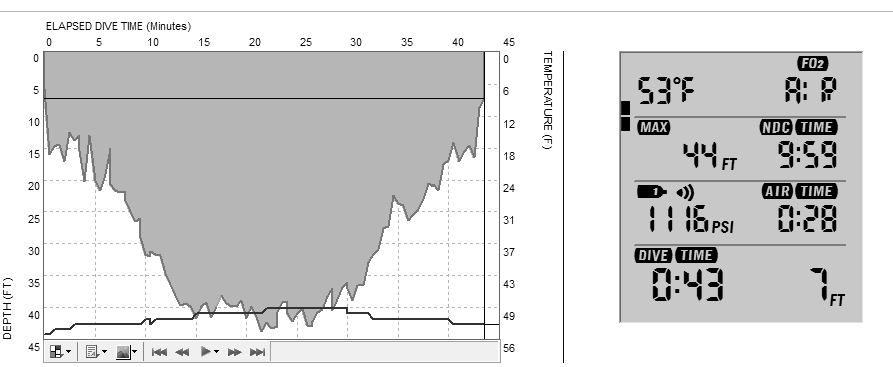
Click for fullsize image
Dive Log
| Depth | 43ft |
| Duration | 43min |
| Temperature | 48F |
| Visibility | 15ft |
PADI DPV Specialty
As I said, I was participating in the PADI DPV Specialty Class. I can recommend the class, it's a great way to get some hands-on time with one of these fun toys without the outlay of cash. You will also learn about the various different kinds of DPV available, and our instructor took us through the various maintainance, assembly and disassembly procedures.This dive site is an above average distance from shore, and reaching it is made much easier with a DPV.
Tuesday, March 25, 2014
Diving in Belize - Hol Chan
One of the sites we dived in Belize was the Hol Chan Marine Reserve.
We did a night dive here.
November 24, 2013 17:26:08
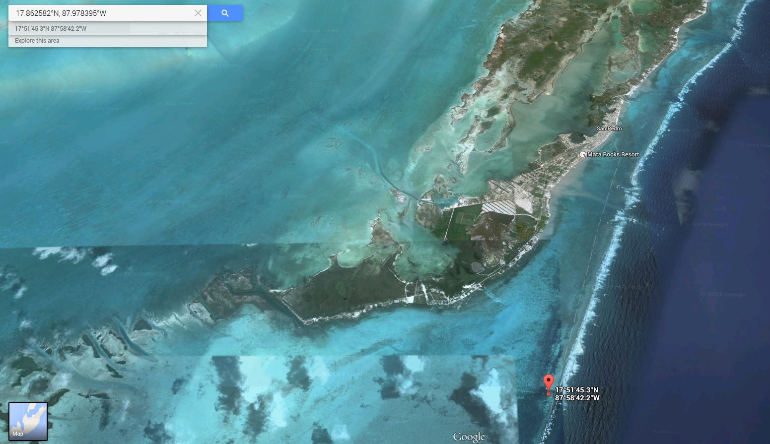
Click for fullsize
View in Google Maps
We did a night dive here.
November 24, 2013 17:26:08
17.862582°N, 87.978395°W
Click for fullsize
View in Google Maps
Sunday, February 9, 2014
Baja plans major 'underwater park' off its coast | UTSanDiego.com Mobile
http://m.utsandiego.com/news/2014/feb/08/rosarito-baja-underwater-park/
Hopefully this will mean some nice, warm water reef, within a days diving distance of home.
Wednesday, January 29, 2014
How is PADI dive society's online magazine so terrible?
I was looking forward to reading this online today. It should be much more convenient than a paper magazine.
I really don't understand how they can make it work so badly.
Stop pretending that my tablet is a Paper magazine, just make the site work like a web page. Let me pinch and zoom, let me flick. Test your shit!
Thursday, November 14, 2013
Diving Point Lobos Nov 2, 2013
Club dive with the dive club of silicon valley.
Excellent day's diving. The conditions had been good for a couple of weeks, so the visibility today was awesome. We dove from MADs inflatable (see also: kamtime) so we were able to get a little further out from the boat ramp than normal.
We dropped down from the boat into about 70ft of water. We could see the bottom as soon as we descended from the surface. It was an unusual experience for Monterey diving, as usually you dive into a murk and the surface slowly emerges to visibility as you get within a few feet of it. Today I had an incredible sensation: On the descent I was at 40ft. I looked down, the bottom looked as though it was maybe 10 ft away, then I looked to my right, I could see my dive buddy a clear 20ft below me, and he looked only halfway between me and the bottom. Sure enough, we touched down into 72ft of water. Incredible.
Both these dives started in approximately the same place. The pin on the map is the location of the first dive. Second dive was slightly to the north-west of the first site.
Dive Site
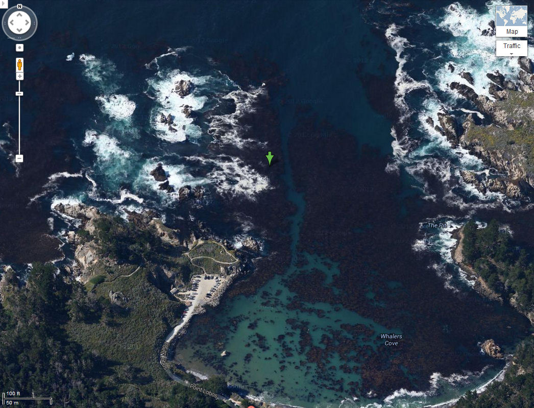
View in Google Maps
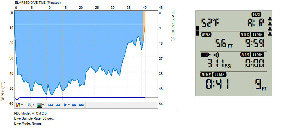
First Dive
Dropped down onto a number of submerged pinnacles. Bottom was around 70ft, but we hovered above that and explored the walls for nudibranch, shrimp, cucumber, etc. We made our way towards the three large rocks visible on the satellite map. We were heading in an approx 300 magnetic direction.
Bottom varied from sandy to "mountainous", with abundant kelp.
Plenty of large schools of blue and black rockfish. It was wonderful to hang in the water column, facing up, and enjoy the views - hundreds of 9-15" fish schooling over head. Spooked a rock wrasse at one point and it flared up its pectoral fins, which were really pretty.
Best view (for us not the creature involved) was a poor old jelly, in about 20ft of water. It was getting picked at by several rockfish. Still pulsating along, but definitely looking worse for wear, it's tentacles were all but gone, and it's bell was looking a little pecked at.
At the half way point we took a reciprocal heading, once we saw the boat overhead we ascended. Kari was waving at us from the surface, she said she could see us 20ft down on our safetly stop.
| Depth | 56ft |
| Duration | 41min |
| Temperature | 52F |
| Visibility | 40ft |
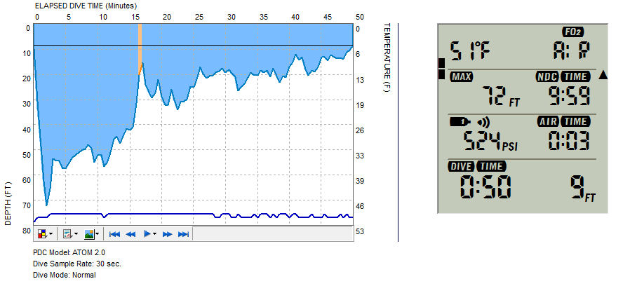
Second Dive
Similar to the first, thought the descent point was slightly north-west of the first.
Took a 300 magnetic heading towards the three rocks again. As we got shallower conditions got a little more surgy.
We were not getting picked-up by the boat this time, so rather than taking the reciprocal heading we instead turned on an approx 150 heading to return to the cove and do a shore exit. We made the turn to 150 at approx 15 minutes. As you can see, I was in around 20ft of water at that point as the bottom was getting shallower towards the wash rocks.
Again, the marine life was mainly rockfish: Large schools of blue and black, a couple of vermillion. Saw a couple of lingcod on this dive and a sheephead. Surprisingly no seal action today, unlike two weeks back.
Returning to the boat ramp was fairly easy, once you start heading in on a 150 heading just keep the shallows to your right and skirt between rocky wall and sand channel (on your left).
As always, the visibility dropped drastically as we got close to the parking lot, that's your cue that it's time to surface.
| Depth | 72ft |
| Duration | 50min |
| Temperature | 51F |
| Visibility | 40ft |
Friday, November 1, 2013
Belize Scuba Diving Trip - Shopping List
Couple of things I'd like to buy before we head out to Belize in November:
Hero 3+
Got to get a good video camera to capture all our underwater and jungle antics!
Spare Air
I am paranoid these days about being in an Out Of Air situation ... probably because I'm diving a lot with my 13 year old son and I can't afford to have him die on me.
Light and Motion Sola 1200
I'm perfectly happy with my SL4, but these Light and Motion and so damned bright. Great for night dives ... though I know from past experience that in the clear blue waters of the Caribbean you really don't need 1200 lumen, even on a night dive.
Hero 3+
Got to get a good video camera to capture all our underwater and jungle antics!
Spare Air
I am paranoid these days about being in an Out Of Air situation ... probably because I'm diving a lot with my 13 year old son and I can't afford to have him die on me.
Light and Motion Sola 1200
I'm perfectly happy with my SL4, but these Light and Motion and so damned bright. Great for night dives ... though I know from past experience that in the clear blue waters of the Caribbean you really don't need 1200 lumen, even on a night dive.
Sunday, October 13, 2013
Diving Monastery North, September 8, 2013
Dive Site
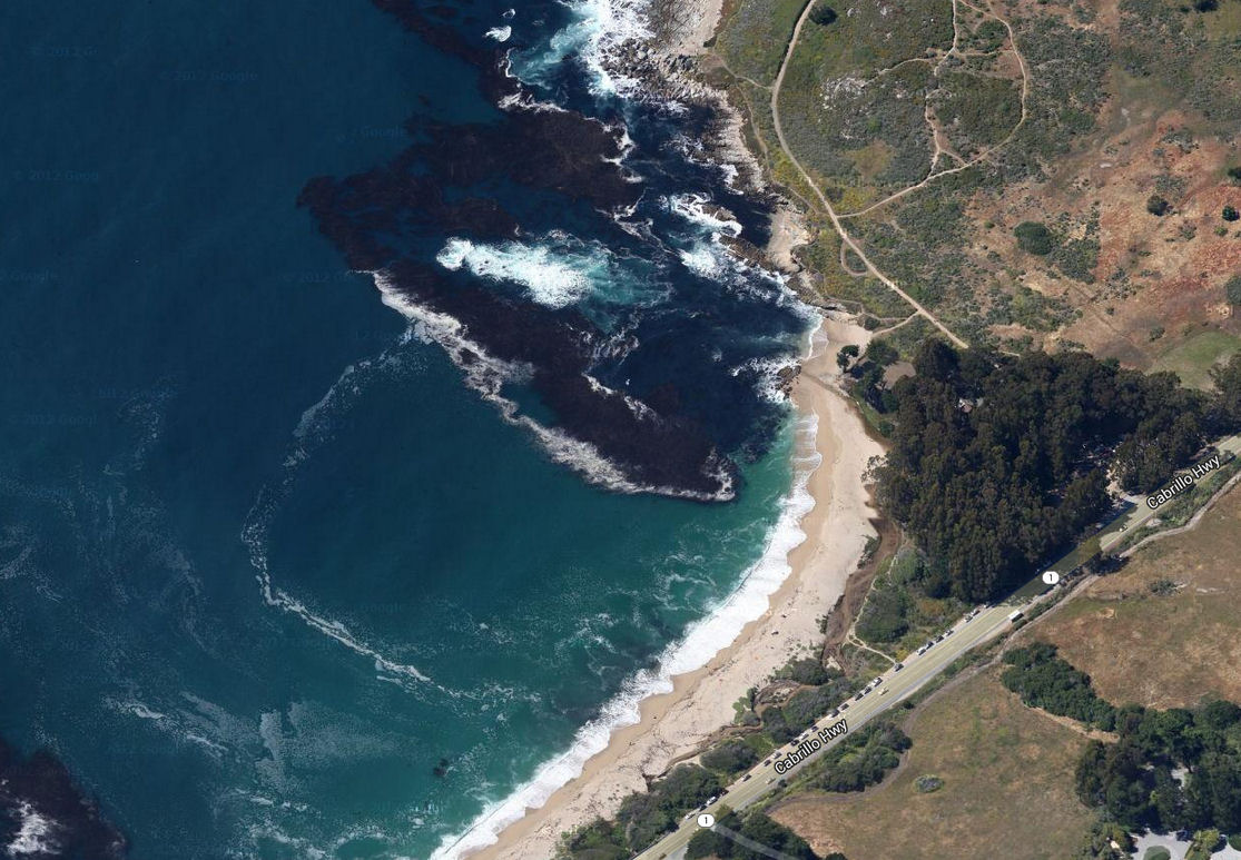
View in Google Maps
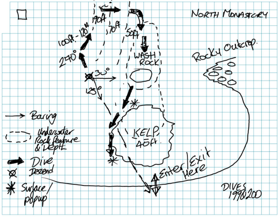
First Dive
| Depth | 121ft |
| Duration | 35min |
| Temperature | 47F |
| Visibility | 20-30ft |
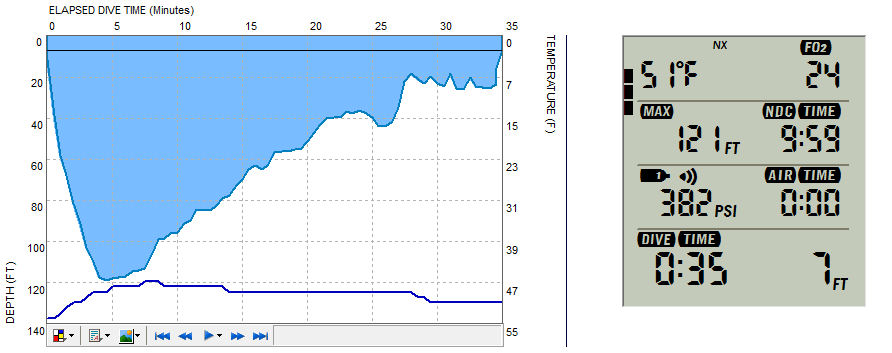
Second Dive
| Depth | 94ft |
| Duration | 50min |
| Temperature | 47F |
| Visibility | 30ft |
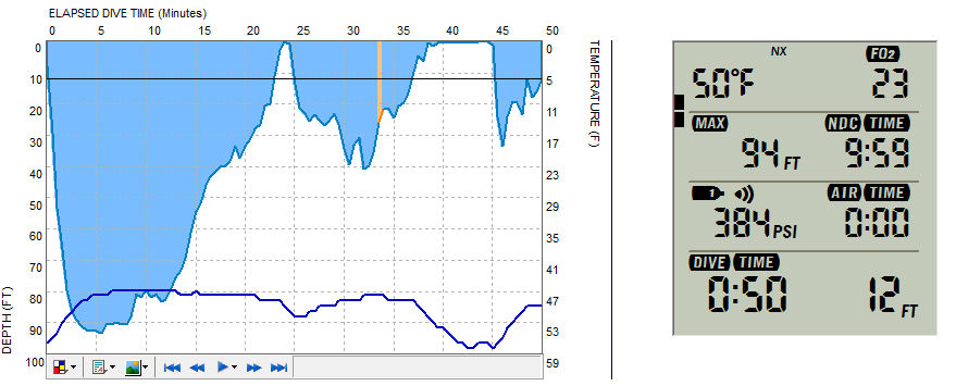
More Info
Other dives at or near Monastery: ukdiveboy.com #MonasterySunday, October 6, 2013
sanctum 3D
http://www.vudu.com/movies/#!content/195974/Sanctum-3D
Almost scary enough to put me off diving ... I said ALMOST!
Almost scary enough to put me off diving ... I said ALMOST!
Saturday, September 14, 2013
New Toy - Nautilus Lifeline
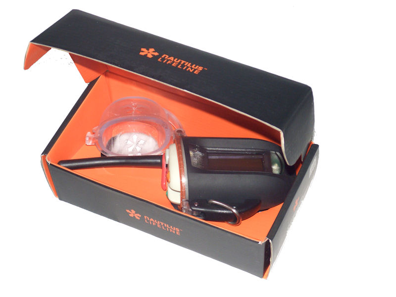
Finally got that Nautilus Lifeline that I've been dreaming of for years.
View larger image
Full report to come shortly, once I've had chance to play with it a little!
View larger image
Full report to come shortly, once I've had chance to play with it a little!
Thursday, August 1, 2013
Post Dive Destination for Monterey
After our last couple of dives at the breakwater, on Cannary Row, we have adjourned to this place.
Massaro & Santos
32 Cannery Row, Suite H-1
Monterey, CA93940
Coast Guard Pier
http://www.massaroandsantos.com
They have a very reasonably priced "Diver Special". But we usually forgo the included soda, and enjoy a cocktail.
Massaro & Santos
32 Cannery Row, Suite H-1
Monterey, CA93940
Coast Guard Pier
http://www.massaroandsantos.com
They have a very reasonably priced "Diver Special". But we usually forgo the included soda, and enjoy a cocktail.
Sunday, July 21, 2013
Diving Point Lobos, July 14 2013
Dive Site
The annual "Day After Dive" for the Dive Club of Silicon Valley. Went diving with 30 or so of my closest dive buddies.
View on Google Maps
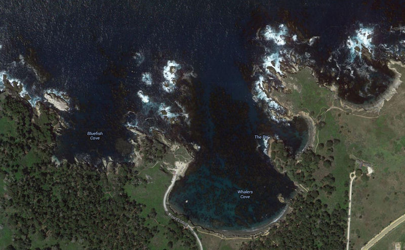
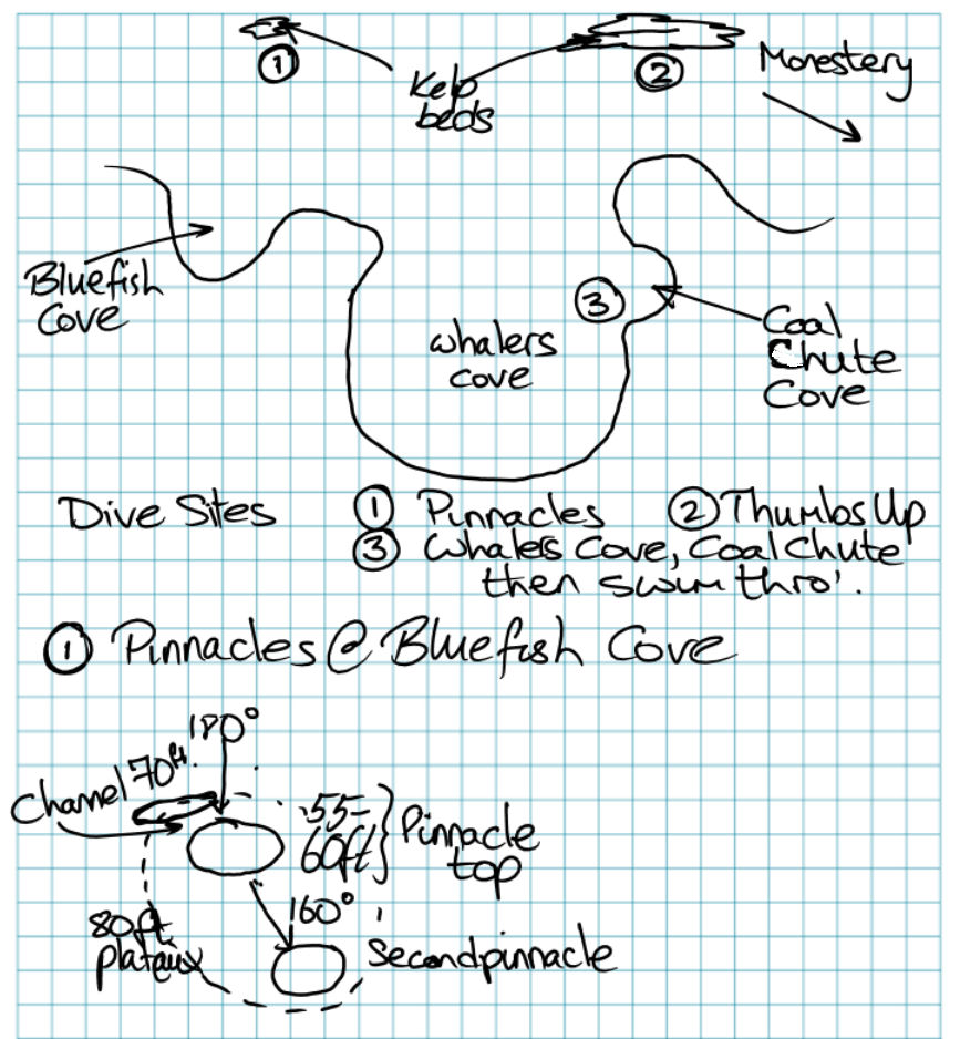
This year we were lucky enough to get a boat charter (actually an inflatable, or RIB) to come drive us out to some less accessible spots, so I did two dives away from the shore. The first at Bluefish Cove Pinnacles, the second at Thumbs Up. After doing two dives from the boat, I managed a third dive from shore, in Whalers cove and Coal Chute Cove.
Click for fullsize
The sights on the two boat dives were similar. I preferred the second site sightly, as it had a more impressive rock structure, the visibility was a little better. The best aspect was swimming upside down at 70ft and looking up towards the surface through some very large school of juvenile red rockfish. We also saw a fair number of large perch, blue rockfish and a couple of reasonable size lingcod hanging out on the rocks.
Neither of these sites are accessible from shore - the surface swim would be too long. Thumbs-up is not a site that I've heard of before. As the map shows, and the captain told us, it's on the edge of Point Lobos, at a place called Mono Lobo. From what I could tell, it's practically at Monastery.
First Dive
| Depth | 74ft |
| Duration | 30min |
| Temperature | 48F |
| Visibility | 20ft |
Second Dive
| Depth | 78ft |
| Duration | 30min |
| Temperature | 48F |
| Visibility | 20-25ft |
After a good long surface interval, we tackled the third dive of the day. By this time, the rest of the dive club members had left, leaving just me and my buddy.
Third Dive
Cave Swimthrough at Coal Chute Cove
| Depth | 33ft |
| Duration | 38min |
| Temperature | 49F |
| Visibility | 20ft |
Click for fullsize
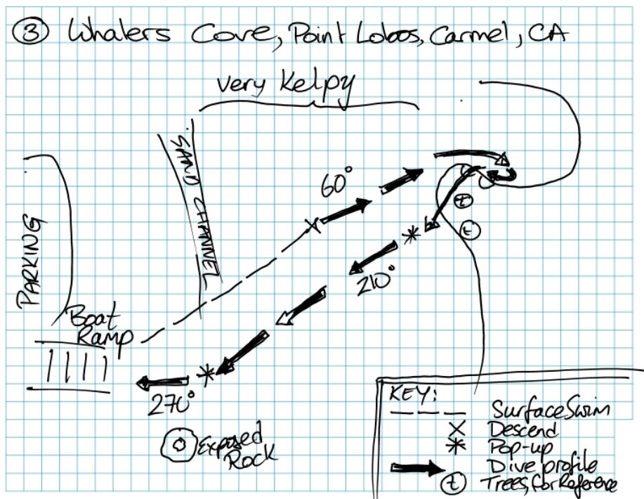
Made an entry from shore, via the boat ramp, into Whaler's Cove. MAde a longish surface swim to the center of the cove, before deciding the kelp was too think to crawl over, and dropping down.
Visibility was pretty good and the views were really nice due to the heavy kelp. Always nice to "fly" through the forest. We were in about 25ft of water at this point. Swam on a 60degree heading towards Coal Chute Cove. The depth got a little deeper as we approached the cove, but only to 33ft.
We hit the corner of Coal Chute Cove perfectly - obvious from the sudden high wall to our right. The sun also started to breakthrough more at that point as the kelp is not so thick over there. We swam a little further into Coal Chute, before turning right (south) to make our way to the edge of the cove.
The purpose of this dive was the swim through the cave. The cave entrance is on the sea floor in Coal Chute Cove, but you exit in Whaler's Cove at the surface.
As always, we were unsure exactly how far into Coal Chute we needed to go. We swam back along the wall, back towards Whalers. We encountered one cave. We swam in. You could see light above, but not a wide enough opening to exit. This was the wrong cave, so we left. We swam a little further, back more towards Whaler's, hugging the cove wall, under an overhang, then to a second cave. We entered. This was a larger cave, with some rubble and a large bolder in the middle. It's initially dark, but once you swim in a little you can see light. There was a slight surge, but we were able to swim through. A little tricky as you have to ascend as you swim through, so there's a change in buoyancy. We popped out into a slightly surgy, slightly wavey Whaler's cove. The last two trees up on the cliff give you a guide as-to where the exit is - I suppose in theory you could make the swimthrough in the return direction, but it would be more difficult - descending into a narrow opening, just below the surface with waves trying to crash you into the rocks.
Due to the short period of time in an overhead environment, this is a dive that requires good buoyancy and at least two flashlights. Provided you can find the cove, you don't need particularly good navigation skills, as you just hug the wall of the cove and look for the opening.
You are force to surface on the Whaler's side of the swim though - as I said, the opening is near the surface. From there we took a new heading back toward the parking lot (220 would have been ideal, we did 210). We dropped back down and swam back across the cove, under the kelp.
Nice swim across. Didn't see much spectacular in the way of wildlife. Visibility was good, until we reached the sand channel at the west side of Whaler's Cove. We swam a little way through the murk, then surfaced. We were still a little way off the boat ramp, so I took a new heading (270) and dropped back down to 10ft and swim in under the kelp.
Great days diving
View from the car across Whaler's Cove towards Coal Chute Cove
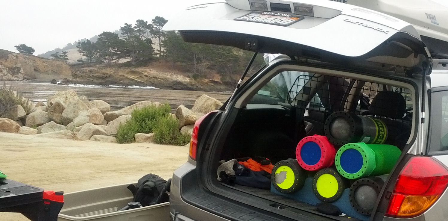
Click for fullsize
Friday, June 28, 2013
Diving La Jolla Cove, San Diego, June 2013
Dive Site
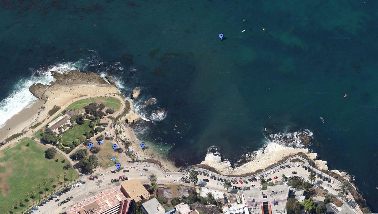
View on Google Maps
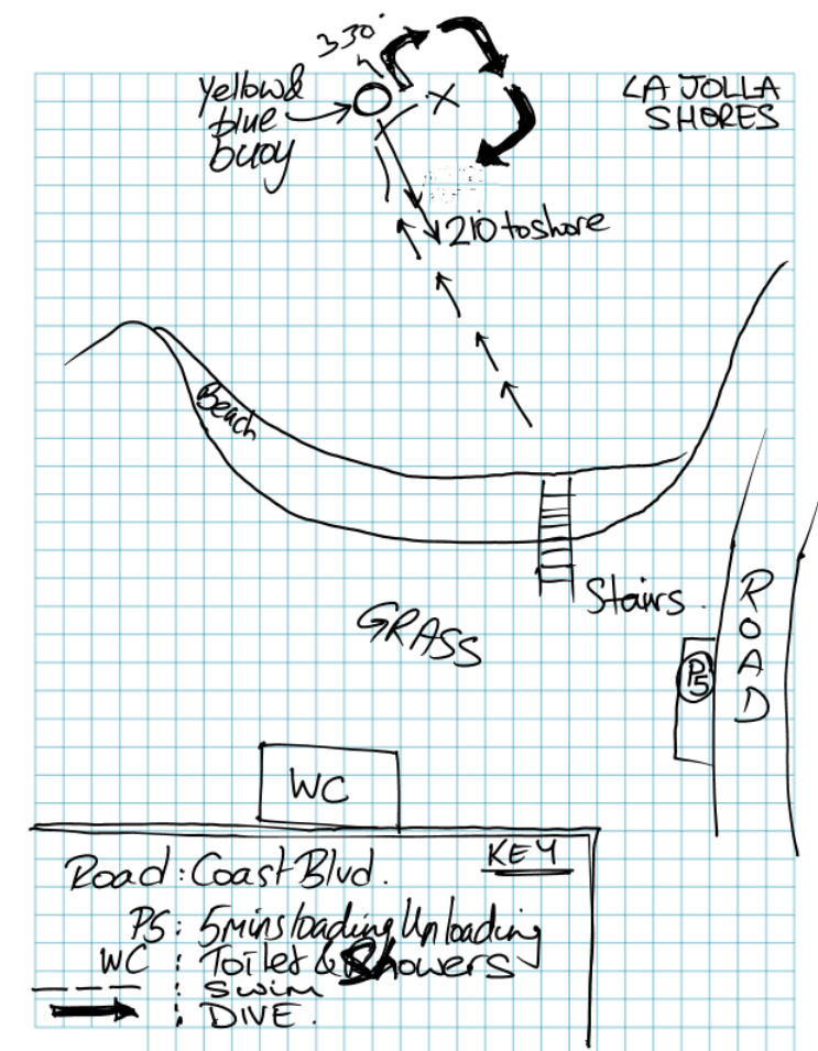
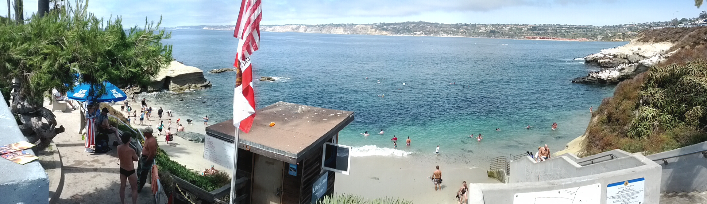
First Dive
| Depth | 40ft |
| Duration | 49min |
| Temperature | 52F |
| Visibility | 15ft |
Second Dive
| Depth | 36ft |
| Duration | 59min |
| Temperature | 62F |
| Visibility | 20ft |
Sunday, May 12, 2013
Carmel River State Beach - May 11, 2013
Dive Site
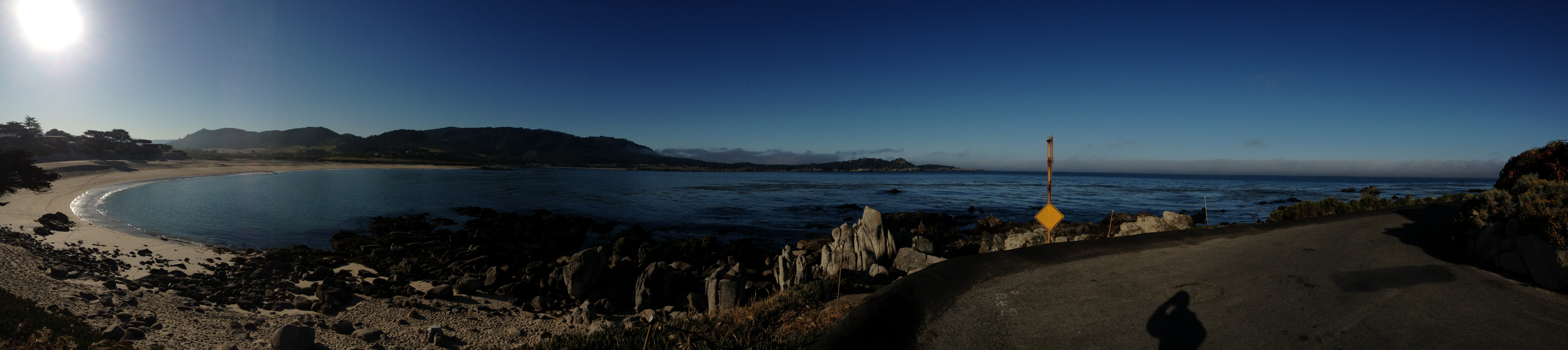
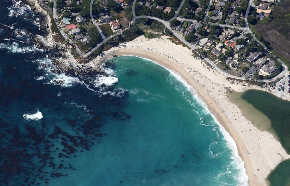
Carmel River State Beach is just North of Monastery. The conditions here can be very dangerous, but if the weather is right, they are brilliant, and today was one of the brilliant days.
We had clear skies, warm weather, flat conditions and great visibility.
Enlarge
View on Google Maps
First Dive
| Depth | 39ft |
| Duration | 59min |
| Temperature | 48F |
| Visibility | 30-40ft |
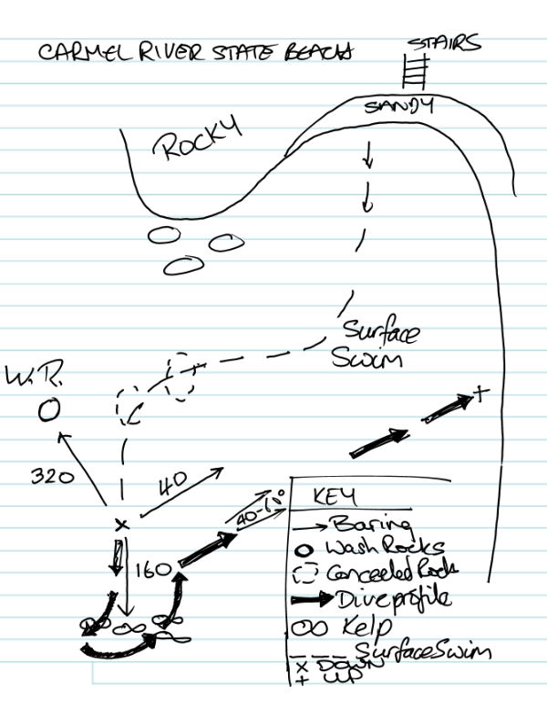
We started by swimming out to the wash rock (which looks a long way out from shore! We figured it would be an interesting pinnacle with a lot of life, so we were going to swim around it and look for critters.
As we swam out, through mild kelp, we noticed a lot of submerged rocks that came very close to the surface, and this was causing some sizable waves, despite the otherwise very flat conditions. As a result we changed our initial plan, and decided to dive the kelp just to the left (as viewed from the beach) of the wash rock.
This was a really nice dive. The floor here was very rocky, with large structures causing the depth to change from 20 to 40 ft. There were numerous bolders to swim along and channels between them making for an interesting dive. The kelp was plentiful, but not too thick, so you could swim through it safely. There was no noticeable surge, so you could swim up close to the walls and get a good look at the marine life.
Saw plenty of yellow Nudibranch, a couple of 'white' ones, several of what I thought were black sea slugs. A few lingcod (3-4ft), cabazone (small), abundant blue rockfish, a few kelp bass, kelp wrasse.
My favorite sighting on this dive was the purple, pink and orange hydrocoral that we saw down at about 30ft. There was quite a lot of it and I don't recall ever seeing that before in Northern California. People have told me that it's common at depth around here though (deeper than 100ft) and I've seen it down south (in the Channel Islands).
Really enjoyed swimming amongst the rock structures on this dive. Circled a couple these, before peeling off on an approximately 40degree heading and swimming in towards shore.
Due to the rockiness of the bottom it was hard to hold the 40 bearing, as a result we drifted south down the beach somewhat. As we got into about 20ft water we were swimming above thicker kelp, then onto a sandy bottom in about 15ft of water. Once we got shallow (15ft) we used the ridges in the sand to guide us into shore and infact pulled ourselves along the bottom on the sand - using the waves to carry us back to shore.
Second Dive
| Depth | 48ft |
| Duration | 45min |
| Temperature | 46F |
| Visibility | 30-40ft |
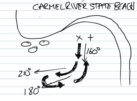
On this dive we dropped down immediately after entering the water - no surface swim. We headed out over the top of the kelp at first, then once depth increased, swam along side the kelp, skirting it down to about 50ft. As the visibility was good, we had an excellent view of the kelp and the sea bed, which was about 10ft below us.
Hit a thermocline at around 30ft, with a very visible shimmer. Didn't see quite as much on this dive as we were further away from the rocks and kelp, but it was a nice view.
On the return to shore we again 'flew' above the kelp for quite a way.
Thursday, April 25, 2013
New Dive Buddy
Yay, I have a new Dive Buddy!
My 12 year old is now certified to dive.
Makes me feel a little nervous.
My 12 year old is now certified to dive.
Makes me feel a little nervous.
Subscribe to:
Posts (Atom)